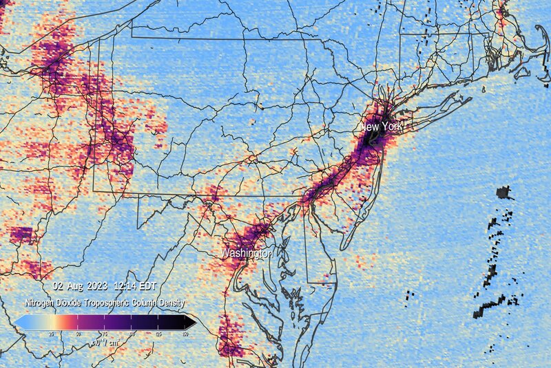
NASA has released the first data maps from its new Monitoring of Pollution device TEMPO that was sent into space earlier this year, according to a press release by the agency on August 24th.
The first pollution maps from the mission that NASA has made public show nitrogen dioxide gas concentrations from pollution around North American cities and significant transportation corridors.
NASA’s TEMPO, or Tropospheric Emissions: Monitoring of Pollution, is the first space-based instrument created to continually evaluate air quality above North America with a resolution of a few square miles from its orbit 22,000 miles above the equator.
TEMPO provides a daytime hourly scan of the lower atmosphere over North America from the Atlantic Ocean to the Pacific coast and from roughly Mexico City to central Canada. It was launched in April aboard a Maxar Intelsat 40e satellite on a SpaceX Falcon 9 rocket.
Data from the TEMPO will improve studies of pollutants brought on by rush-hour traffic, the movement of smoke and ash from forest fires and volcanoes, and the impact of fertilizer application on agriculture.
Scientists will be able to better comprehend differences in air quality within a community with the aid of TEMPO’s observations.









add your comment
Terms of publication : Not to offend the writer, people, sacred things, or attack religions or the divine self, and refrain from racist incitement and insults.