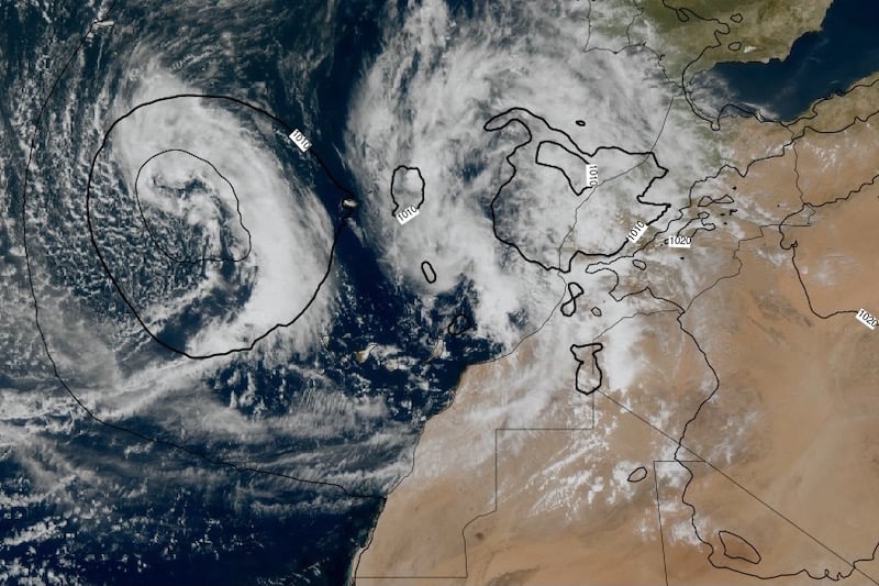
A new Atlantic low-pressure system is expected to approach Morocco’s northern coasts by the weekend, bringing unstable weather conditions across much of the country, the national meteorological authority said Wednesday.
The system, named Olivier, is forecast to strengthen from Saturday through Wednesday, according to the General Directorate of Meteorology. Warm, humid air from the south is expected to collide with cold air masses descending from northern Europe, creating ideal conditions for unstable weather.
Houcine Youaabed, the directorate’s communications officer, told Hespress AR that the collision of air masses would lead to the formation of unstable cloud cover, resulting in scattered rainfall and occasional thunderstorms—particularly over the Atlas Mountains, central and northern plains, the eastern regions, and parts of southeastern Morocco.
Strong winds may stir up dust and sand, especially in inland and desert areas, Youaabed added.
Unseasonably Warm Weather Followed by Cooling Trend
The forecast follows a stretch of unusually warm, sunny spring days and a historically wet March. Temperatures in recent days surpassed seasonal norms by 5 to 10 degrees Celsius, with highs above 35°C (95°F) recorded in interior plains such as Tadla, Rhamna, Souss, and the southern provinces.
Meteorologists attribute this to the influence of Olivier, currently stationed in the Atlantic Ocean off the Canary Islands, which pushed hot tropical air masses northward into Moroccan territory.
However, a gradual drop in temperatures is expected in the coming days, alongside more variable conditions featuring cloud cover and intermittent rain, particularly in the north and northeast.
Starting Thursday, the low-pressure system is forecast to shift toward Morocco’s western Atlantic coasts, expanding its impact to include northern and central areas.
Rain, Thunderstorms, and Snow in the Forecast
According to Youaabed, the country will experience a gradual shift to unstable weather conditions, including rainfall over the High Atlas Mountains and its eastern slopes, along with isolated showers—potentially thunderous—over northwestern regions.
Snowfall is expected to continue over the High and Middle Atlas peaks, particularly during nighttime and early morning hours, due to cooler mountain temperatures.
Minimum temperatures are forecast to range from 5°C to 11°C (41°F to 52°F) in the Atlas and Rif Mountains, and between 10°C to 15°C (50°F to 59°F) elsewhere. Daytime highs are expected to reach 27°C to 32°C (81°F to 90°F) in the southern plains and 16°C to 21°C (61°F to 70°F) along the Mediterranean and northeastern coast.
By Friday, cloud cover is expected to blanket much of the country, with possible rainfall in the Atlas and southeastern slopes, as well as light showers over Saiss and the Rif region. Dust storms are likely to persist in the southern parts of the eastern region, with a slight increase in temperatures anticipated.
Wednesday’s weather already reflected these shifting patterns, with mostly cloudy skies, scattered showers, and occasional thunderstorms, especially in the southern High Atlas and Souss regions. Limited snowfall is also expected over the Atlas peaks, while moderate winds and local dust storms are likely in Tangier, the eastern region, the southeast, and central Morocco.








add your comment
Terms of publication : Not to offend the writer, people, sacred things, or attack religions or the divine self, and refrain from racist incitement and insults.